Distribution


Contents
News
Trees
Documents
Distribution
Problems
DeFixby
Resources
Links


International Comparisons


Great Britain top area (1881)

Huddersfield

Great Britain top area (1998)

Huddersfield

Great Britain top postal town

Huddersfield

Australia top state

Tasmania

Australia top standard statistical division

Far North, South Australia

New Zealand top province

Canterbury

United States top state

Rhode Island


Great Britain

1881

1998

Change

Occurrences per million names

91

76

-15


Information taken from the National Trust Website
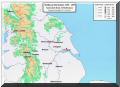
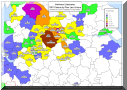
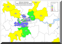
: ( www.nationaltrustnames.org.uk )


Banner Text   Maps   Banner Text


Seven maps are reproduced showing the distribution of the Mallinson name in England & Wales.


Map 1 shows the distribution of the Earliest known Mallinsons.


Maps 2 - 7 show the distribution of the Mallinsons using data from the 1881 census.

anigreen07_next.gif Click on the Thumbnail to View the Map at Full Scale anigreen07_back.gif

    71.png  The Distribution of the Earliest known Mallinsons (1285 - 1547)

    1.png  1881 Census by County (Totals)

    21.jpg  1881 Census by County.


    (Normalised to account for the differences in the county populations.)

    4.png  1881 Census by Poor Law Unions. 


    (Normalised to account for the differences in the county populations.)

    3.png  1881 Census by Poor Law Unions (Named). 


    (Normalised to account for the differences in the county populations.)

    51.png  1881 Census by Poor Law Unions. North of England. 


    (Normalised to account for the differences in the county populations.)

    61.png  1881 Census by Poor Law Unions. Greater London.


     (Normalised to account for the differences in the county populations.)

[Home] [Contents] [News] [Trees] [Documents ] [Distribution] [Problems] [DeFixby] [Resources ] [Links]

Copyright (c) 2001-2008 J.S.Mallinson. All rights reserved.